Island Crest Way Corridor Safety Analysis
Share Island Crest Way Corridor Safety Analysis on Facebook
Share Island Crest Way Corridor Safety Analysis on X (formerly Twitter)
Share Island Crest Way Corridor Safety Analysis on Linkedin
Email Island Crest Way Corridor Safety Analysis link
Consultation has concluded
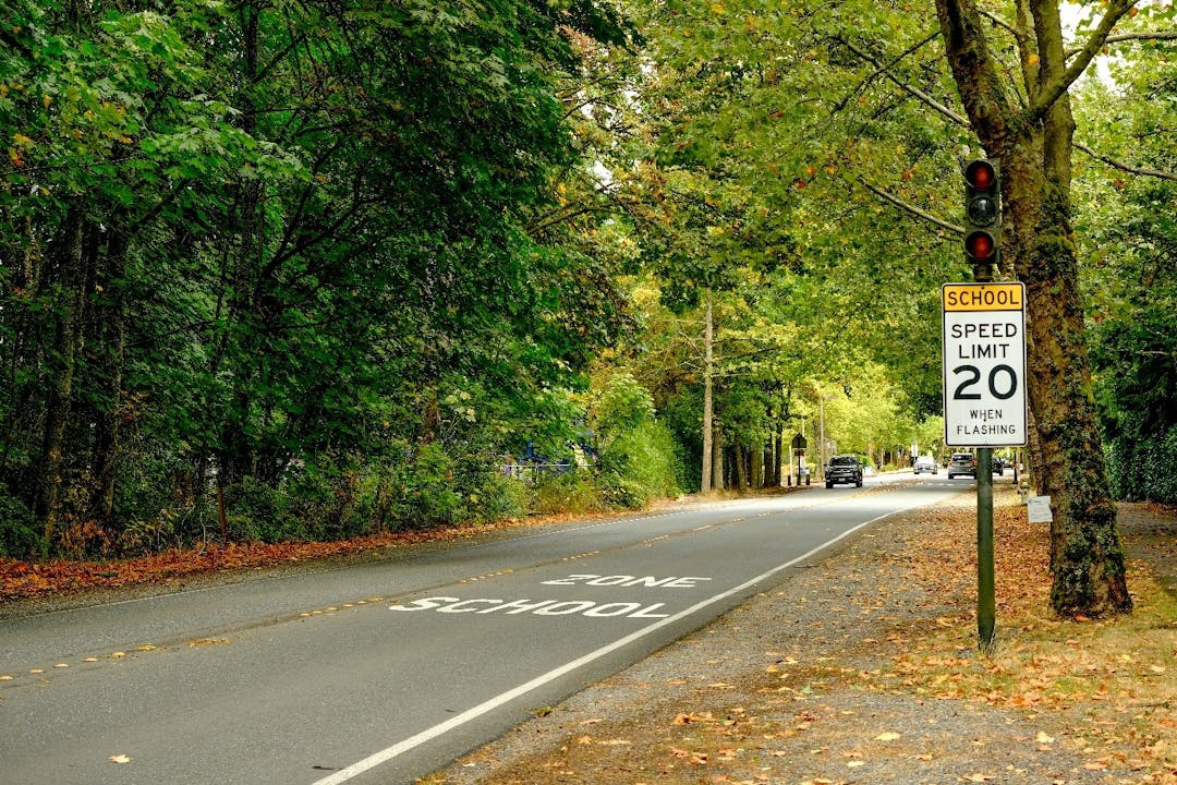
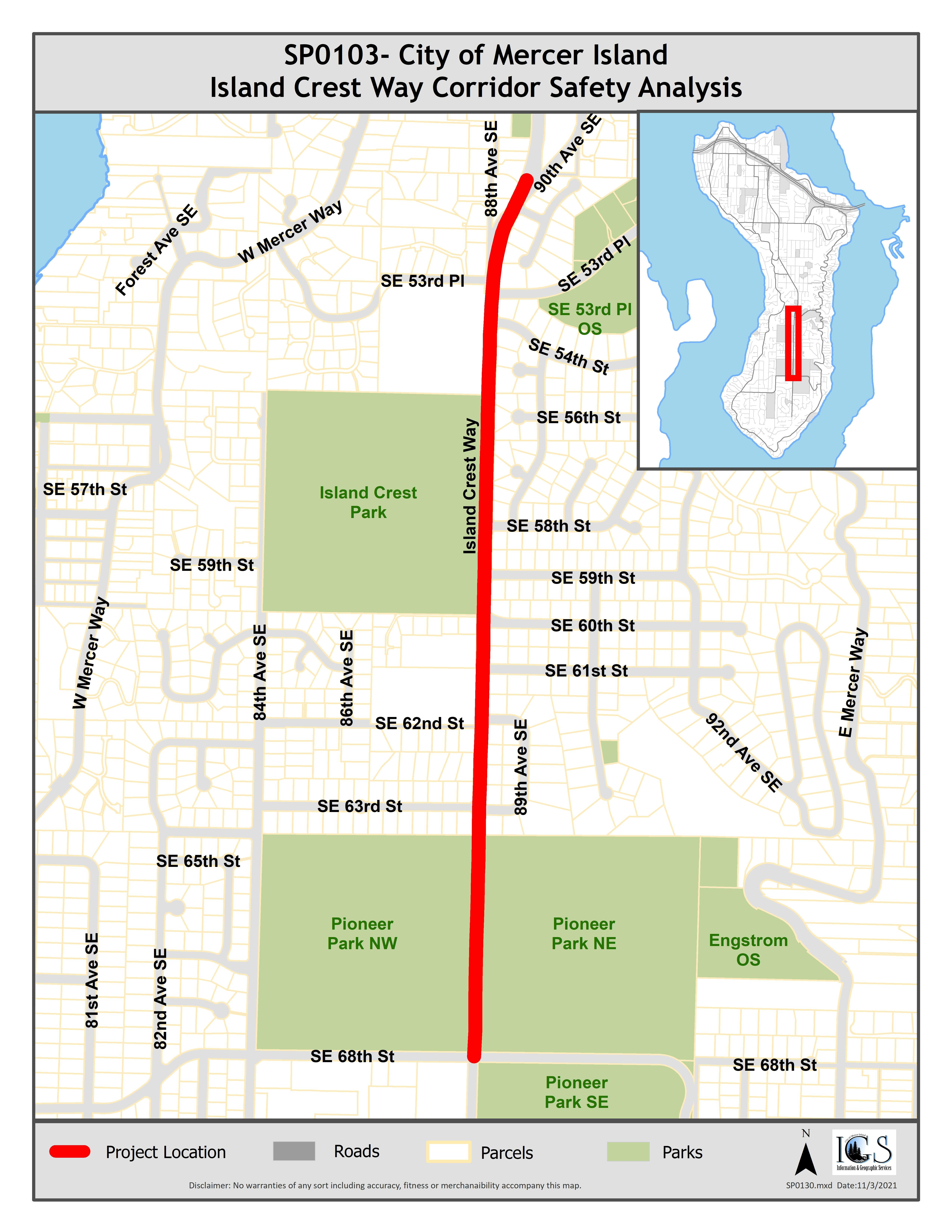
A one-mile section of Island Crest Way, from 90th Avenue SE to SE 68th Street, is a vital connection to schools, parks, ballfields, places of worship, commercial centers, and Interstate 90. The Island Crest Way Corridor Safety Analysis aims to identify and evaluate safety issues for all users of this corridor and provide a roadmap for improvements.
Have you ever found yourself feeling uneasy walking along Island Crest Way, concerned about visibility when turning from a side street, or have other safety concerns on this section of Island Crest Way? We conducted a community survey in December 2021 to identify areas needing improvement.


This survey had way too few responses to be valid. Plus the answers were quite vague in the end, and did not suggest any kind of safety concern. I learned almost nothing from the survey, except maybe this is a solution in search of a problem in the eyes of even those who responded.
The survey certainly does not support that any significant majority of users are bicyclists. In fact most kids get to school by car or school bus. Over 86% use ICW in a car. It also did not reveal the millions it would cost to place bike/pedestrian trails along either side of ICW, the number of trees that would be removed, or the problem with a 10' wide mixed use path that is bi-directional.
The city has been through this many times. The last time the council addressed this during the TIP Yamashita plainly stated he would not pursue it because the stakeholders -- Island Park Elementary, the neighbors along ICW who demand the vegetation screening, south end residents who love the tree canopy, the huge number of access drives and neighbors who don't want more lighting -- just make a solution nearly impossible, and he had wasted too much time on this with Grausz in the past.
There is no solution -- at least the north/south bike path -- to the west because Island Park is opposed to having adult bicyclists ride across the western edge of the playground which is the farthest away from supervision, and there is a ravine, and 84th would likely have to eliminate street parking. The only other solution is to the east of ICW, but I just have not seen a workable proposal in the 15 years this issue has been pursued. Most bicyclists I know use the Mercers.
I do think the intersection at 68th could be improved.
Yamashita was right. For the last 15 years someone on the council or in the city resurrects this idea, ordinary citizens don't participate during the scoping, and then the city holds some kind of public meeting (when it held public meetings) and the south end residents and parents taking their kids to and from school and the neighbors along ICW go ballistic, because there is no solution if Island Park is opposed to a trail on the west side of ICW, the neighbors are opposed to removing the vegetation screening their neighborhoods that require every driver to pull out over any proposed bike train to enter ICW or exit at 45 mph, the result at best is a 10' wide mixed use path that is bidirectional and would cross every access drive, the south end residents oppose removal of any of the tree canopy, and like this survey and the comments the number of stakeholders pushing this idea turn out to be very low.
If anything has been learned over the last 15 years it is let the citizens know what the city, council, or folks pushing this really plan for design, because we all know what the design is behind this survey. In the past it was the design the citizens objected to. We all understand the issues, and what some folks want, although the survey suggests they are not that pressing, but the objection is always to the solution.
The safety study supports what the city's previous two Pedestrian/Bicycle Plans have called for since 1996: a safe trail connecting running down the center of the island connecting our schools and the rest of the island with the city center. The proposed bike/pedestrian path is the key 'missing link' that would benefit the entire isl.and.
Even better that path should run south at least to 68th Street if not down to 71st to connect with the wide shoulders on 71st street.
I love the ICW and 68th round-a-bout future plan! It will make a safer path for pedestrians (seeing where the crosswalks will be located). Plus, drivers will have a much smoother transition to their destinations, especially during peak hours. A round-a-bout will also open the space up more, allowing for more visibility in this dark intersection.
A 10 foot wide bike/pedestrian path on the east side of ICW is a great idea since e-scooters and e-bikes are becoming more popular. Walkers, bikers, and cars all need a safe, wide path.
Lighting up ICW is a top priority- it's too dark and dangerous at night and early morning. Especially near Pioneer Park where there are no homes to help light the way.
Thank you for allowing the public to post comments!
When making a left turn from SE 63rd St onto Island Crest Way, cars or trucks sometimes block visibility by parking near the northwest or southwest corners of the intersection. When that happens, it is difficult or impossible to safely enter traffic. There is a no parking sign at the northwest corner of the intersection, but the vehicles that park there are often utility or city vehicles. They also sometimes park at the southwest corner (near the bus stop) which blocks visibility of northbound traffic. If a vehicle must temporarily park there, they should make certain they’re not blocking visibility or have a person directing traffic.