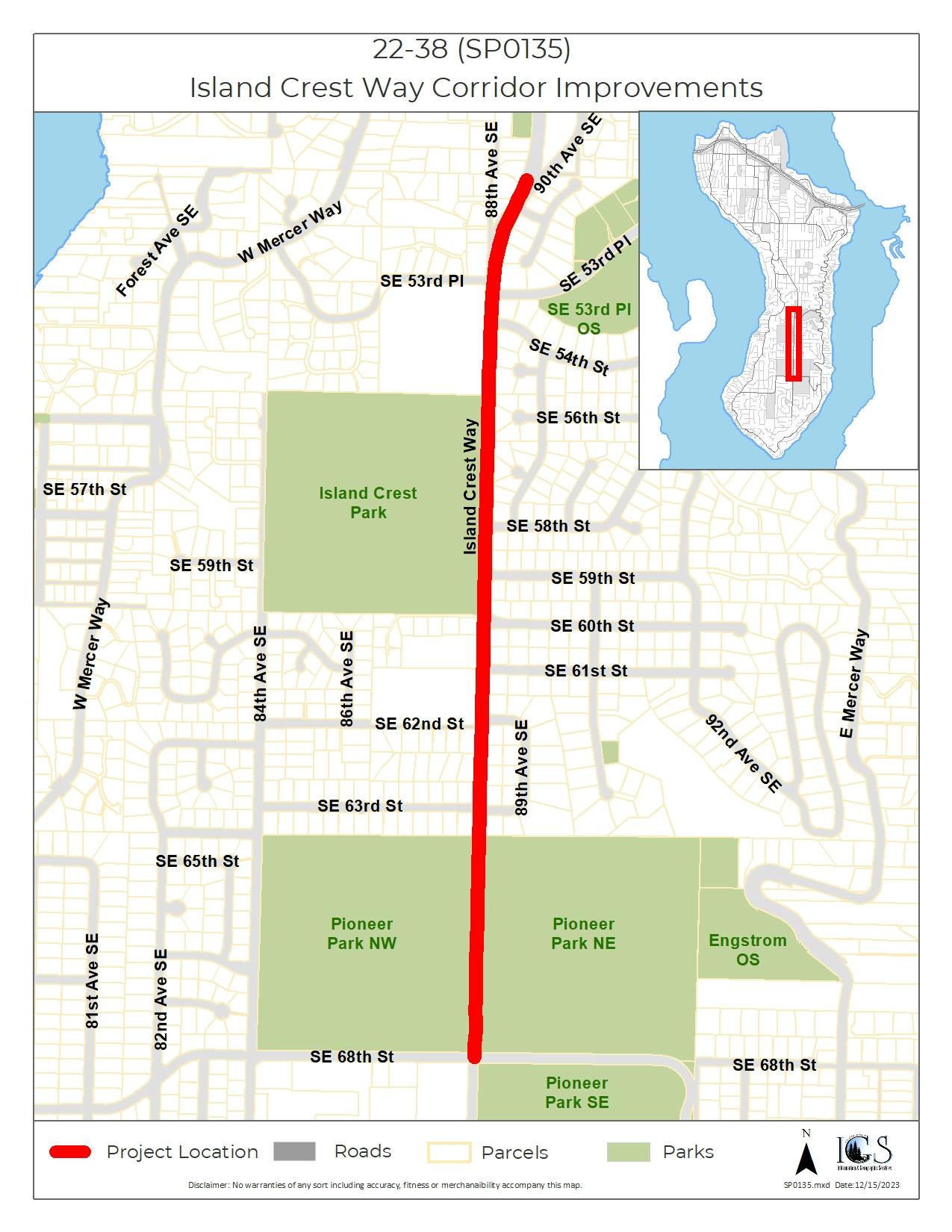
Island Crest Way Corridor Improvements
Project Overview
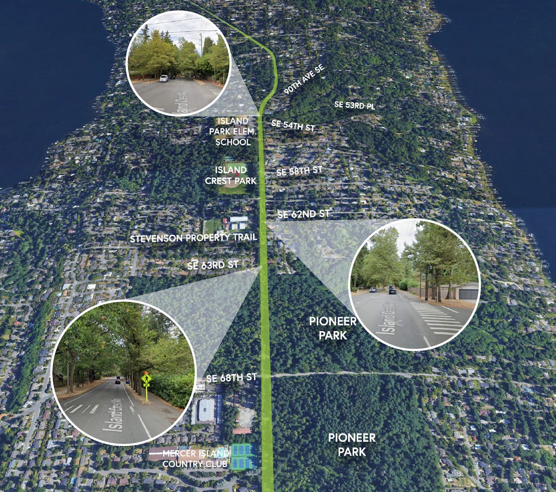
Island Crest Way (ICW) serves an important north-south corridor through Mercer Island, providing vital connections to schools, parks, residential neighborhoods, places of worship, and commercial centers, as well as access to I-90.
In 2022, the City conducted a corridor safety analysis. This extensive study included community input which helped the City identify recommendations and solutions to address pedestrian, bicycle, and vehicle safety concerns. The findings resulted in the Island Crest Way Corridor Improvements Project to enhance safety along Island Crest Way from 90th Avenue SE to SE 68th Street.
The City is now embarking on the second stage of the project where we begin the design and implementation of some of the recommendations made in the previous stage. To cover a wide range of factors and goals, this project has been broken up into several components.
Project Components
- ICW Shared Use Path Improvement Project: Assess feasibility and begin preliminary design on a shared-use path for pedestrians and cyclists. This proposed path will complete the missing section of the bicycle route along Island Crest Way between 90th Ave SE and SE 63rd St. The ICW Shared Use Path Improvement Project is the City’s current focus and will include public outreach and input from the community.
Other project components include:
- Tree Condition Assessment: Every tree along the corridor is being assessed by certified arborists to document growth conditions and ensure the preservation of healthy trees and root systems.
- Illumination Study: A corridor-wide lighting assessment to explore adequate lighting solutions and design recommendations for all roadway users.
- Crosswalk Improvements: Design of enhanced pedestrian crossings at three locations to be constructed in 2024, including Island Park Elementary School Crosswalk, SE 62nd Street & SE 63rd Street.
- Feasibility Study & Concept Design: Evaluate the feasibility of two intersection modifications: a roundabout or other improvement at the intersection of SE 68th Street and Island Crest Way and a westbound right turn lane at the intersection of SE 53rd Place and Island Crest Way.
Project Goals
- Improve safety along the Island Crest Way corridor by designing more dedicated marked crossings and enhanced lighting throughout the corridor.
- Develop a multi-modal corridor that provides safe and efficient movement for pedestrians, cyclists, and drivers.
- Provide essential connections to existing trail systems along the corridor and safe crossings to these trails.
- Encourage community members to help the City clearly identify the existing issues and explore opportunities to meet project goals.
- Improve access to transit along the corridor.
- Preserve the urban forest and the existing tree canopy while balancing safety and available right-of-way space to achieve project goals.
Get Involved
The online open house has been postponed to provide a project update and preliminary draft of shared use path alternatives to the City Council for feedback and a decision on their preferred alternative. The City Council's direction will inform the next steps of the design and public engagement process. City Council agenda bills regarding this project will be linked to Let's Talk the Thursday before the City Council meeting.
Post a Public Comment
I strongly support option #1 for a single lane roundabout at the south end intersection of 68th/Island Crest Way. Living on the southend, I walk through that intersection frequently and having an "refuse island" (option #2) to stand between lanes is dangerous and doesn't fix the current problem. That "refuse island" is the main reason I don't feel safe in that intersection- it's no refuse, it's just plain scary with cars zipping around every which way. Plus, kids riding bikes/scooters at this crossing don't have enough space to start/stop on bikes on a small "refuse island."
Option #1, even though more expensive, is the right choice for the long term for that intersection. Plus, it looks more streamlined, cleaner and less confusing than #2. Landscaping or a large piece of art could be in the center of the roundabout- like a "welcome to the southend" feeling that the north end typically has. The south end tends to get neglected in that respect.
Option #2 would improve things temporarily, but that "refuse island" is always going to be a big safety issue with that intersection. Better to do it right the first time. Thank you!
Opposed to a roundabout at 68th/Island Crest Way. Not enough room. And have seen aggressive driving at other roundabouts like the one at 77th and North Mercer. Not everyone obeys the yield signs. If you can’t afford a signal, leave the 4-way stop signs and have MIPD enforce them.
Why is the council being asked to approve the design and construct the Island Crest Way Shared Use Path Phase 1 project? Doesn't that sound like it is a fait accompli before you have even asked the neighbors what they think about it? If you commence this construction, and neighbors are against the project going ahead, what happens then? Will you tell them, oh, it is too late as we have already commenced construction? And does this Phase 1 project remove any mature trees and if so, how many? And just to accommodate 50 bicyclists and possibly 300 pedestrians a day. For such a small number, they could just use the sidewalk.
The following is a fairly deep dive into the ICW missing link, as well as some comments about changes to the park and ride bike lane, and the crosswalks at SE 62nd and SE 63rd.
Of particular note is that the ICW recommendations essentially stop across from IP school on the north end; and at SE 63rd on the south end, despite the map showing the route going south to 68th. That’s accurate only because the route would force cyclists going both directions to share the existing, narrow asphalt path in the NE section of the park.
More details and analysis follows.
NIM (Neighbors in Motion) offers the following comments on the TIP and the Pedestrian Bicycle Facilities Plan (the “Plan”). We are very concerned that these documents will make cycling on Mercer Island worse, increase the dangers of accidents and injuries, and create future confusion about important cycling-related projects that are killed or buried. We begin with the historic fact that the TIP and the PBF were not coordinated. This disconnect continues this year, so we may need to update these comments to the extent the City and council incorporate the PBF with the TIP projects. Our hope is that the pending PBF contains specific projects and a timeline for their completion, and that those projects and deadlines appear in the TIP.
Of most importance is progress on the ICW Misslng Link not be delayed for years by a new PBF as in the current TIP. Two PBF plans have identified this project and City staff, council members and residents have expressed their support. The consultants recently issued an initial report. The public comments repeatedly point out that safe cycling routes to and from the schools and other Island destinations are a priority for citizens. The omission of the Missing Link project makes it appear that Mercer Island is not interested in cycling and its citizens who bike. This project should be included and should be given the highest priority.
The following projects are slated for this year in the Plan. Many of these overlap with the ICW missing link. These suggestions could significantly reduce the cost as well as the number of trees to be removed on the missing link project.
“NMW '3 Transit stop.” This proposes to eliminate the bike path (make it peds only), require bikes to dismount, and sign bikes to reroute. This is unrealistic and ignores reality. This area links two I-90 bike paths. The natural flow for cyclists is right through the bus stop area. The fact is that cyclists (particularly from off Island) will go through the North Mercer bus area as they do now. We know from experience that they are unlikely to dismount absent police enforcing the rule. Purporting to “eliminate” bikes will mean pedestrians will no longer watch for cyclists and therefore increase the risk of an accident and a costly lawsuit against the City. The better course is to leave the area as it is, improve the green paint markings on the sidewalk, and post speed limit signs for cyclists. Without some improvements, it is highly likely there will be unacceptable results absent constant monitoring.
NORTH END OF ICW MISSING LINK
The following comments apply to the north end of the Missing Link project
“ICW 1, ICW 2, ICW3”. This would possibly add bike lanes along ICW from I-90 to 53rd, when the road is resurfaced. That section of ICW has wide shoulders, easily adaptable to bike lanes. That makes sense. But this recommendation highlights a problem with the consultants’ report for the north end of the missing link. That is, the report basically ends the west side missing link route on ICW south of IP school, and any improvement to the east side route ends across from the school. The report presumes bikers from the west side of ICW heading north will cross ICW and continue on the east side on a narrow sidewalk (8’?), jockeying for space with southbound bikers and walkers, adults with strollers, and parents walking children to schools, going both directions. The east side bidirectional route suffers the same basic flaw.
Adding those bike lanes along ICW north of 53rd is a good idea, and would dovetail nicely if the ICW missing link is one way on each side of ICW, as these lanes likely would be. That could be by building the separated bike lanes along each side of ICW. Or, one way bike lanes could be built on each side of ICW using the existing path (west side) and existing sidewalk (east side). Peds could use either side, going either direction. If this choice is adopted, compact gravel could be used on the west side, at considerable cost savings. Possibly the route on both sides of ICW could be narrowed to 9’, to reduce tree loss. But whatever choice is made, the ICW missing link needs to be completed north of IP school, especially on the west side, so it will connect with the bike lanes along ICW north of 53 when they are installed.
Additionally, just north of IP school, the current city-marked route directs cyclists going south on 90th to cross oncoming traffic—often teens driving to or from the high school—to get to the marked route on the east side of ICW behind the mailbox at SE 53rd. Then cyclists have to deal with other cyclists coming at them, as well as walkers going both directions on that narrow sidewalk, to cross ICW to get to the school, bike skills area, etc. It would be much safer to install a new crosswalk at ICW and 90th so cyclists could safely use the completed west side of the missing link. Unless and until a crosswalk is installed at ICW and 90th (or the route is redone as noted in the next paragraph), the existing southbound bike route on 90th should clearly mark, preferably with green paint, where those cyclists are to cross 90th to the mailbox.
An alternative is to continue the east side route another quarter mile or so north along ICW from 53rd, when those shoulders have been converted to bike lanes. Bikers could continue north on ICW or turn onto 89th SE toward the library, etc.—instead of riding on 90th—and a new crosswalk would be installed at ICW/89th/47th. Southbound bikers not riding on ICW (e.g., those coming from the library or Boys and Girls Club) would ride on SE 89th instead of 90th and use that new crosswalk at 89th to continue south on ICW on the redone shoulders. If this is the plan in the foreseeable future, a new crosswalk at 90th might not be necessary. Or it could be built at 90th, then relocated to 89th, when the ICW shoulders are installed.
SOUTHERN PART OF THE MISSING LINK
The following comments apply to the ICW Missing Link at or south of SE 62nd.
“X 15.” ‘A new crosswalk at SE 63rd’. There is already a crosswalk at 63rd. Is this supposed to be SE 62nd, which does need a crosswalk, as the consultants recommend?
The current crosswalk at 63rd should be relocated to the south side of its intersection with ICW. That would be safer for pedestrians, especially those walking between the two north segments of Pioneer Park. Walkers would not have to deal with the majority of drivers who use 63rd to turn north onto ICW—right into the current crosswalk. (Most of the peds jaywalk instead of going far out of their way to use the existing crosswalk to cross ICW.)
The consultants’ report also virtually stops the project at SE 63rd. Both cyclists and pedestrians are expected to cross ICW and use the existing, narrow asphalt path in the NE section of Pioneer Park; both cyclists and walkers going both directions. Obviously, that is a recipe for conflict. More likely, cyclists riding north or south will use the dirt path in the NW section of Pioneer Park to continue on the west side of ICW, instead of crossing ICW. If the separated lane alternative is chosen, this is not a problem. If the bike route is one way on each side of ICW—as discussed above—a narrower (9’?) path in Pioneer Park, continuing the crushed gravel path on the west side, might be adequate. On the east side of ICW, having bikes go one way/northbound in the NE section of the Park should reduce conflict. The existing sidewalk in the park could be widened, or crushed gravel installed on one or both sides of the sidewalk.
“S10.” The city would spend money to remove the current bike lanes on SE 71st in front of MICC. They’re already barely visible and totally ignored. That’s a waste of money.
Projects awaiting a new PDF plan.
Should the missing link at least be mentioned as a line item?
“ICW 5 & ICW 6.” Apparently, these would pave the existing dirt paths south of 68th to 77th at a cost of over $160k. It seems gravel would be just as effective and cheaper--for paths that don’t get a huge amount of use.
That area is also ignored by the consultants’ missing link proposal, probably pending what is done at ICW and 68th. But in the meantime, instead of bikers going straight down ICW south of 68th to 77th—which would bypass IMS— there is a much flatter and safer route through the neighborhood that accesses both IMS and Lakeridge. All that is needed is signage and sharrows.
NIM is anxious to convey these ideas to the city—Patrick Yamashita, Jason Kintner, relevant city commission(s)—before these items and the missing link project get too far down the road. We look forward for a report on ICW Missing Link to be issued and hope to work collaboratively on whatever proposal is chosen.
Respectfully,
Kirk Griffin for
Neighbors in Motion
I just read the comment from Jstan below... Yes, I strongly agree the new bike/pedestrian lanes should include the "Safe Routes to School." Kids are using E-bikes and scooters so much there should be a focus on these new forms of transportation being in safe lanes, especially around the schools.
The new bike/pedestrian lanes should follow this route:
1. Start at Lakeridge Elementary, 84th Ave SE, go north, past Islander Middle School
2. Turn east onto 68th, past the south end shopping center
3. Turn north on Island Crest Way (going past Island Crest Park's new bike park) and Island Park Elem.
4 From the light at ICW, turn west onto 40th (past West Mercer Elementary)
5. Turn north on 78th then towards the norht end shopping and new light rail station (opening in 2025).
This route hits the majority of the schools and shopping centers on the island. The current bike/pedestrian path planning should not be so limited in scope, it should encourage safe walking and biking for the whole island. Thank you!
According to the study, 68th St./ICW at the Pioneer Park's 4 way stop is the most dangerous. The roundabout placed here should be a high priority to fix this dangerous section. New pedestrian crossing locations (like shown in the photo of the study) would make this so much safer. It is also extremely dark and needs good lighting all along ICW, but especially at this intersection where it is pitch black at 5:00pm in the winter months.
The south end of the island doesn't have much art work, so an art sculpture in the middle of the roundabout would be a nice feature to welcome everyone to the south end. I've seen art work placed in roundabouts in other communities and it helps unite the area...maybe some metal tree sculptures to highlight the Pioneer Park theme?
I'm concerned the bike/pedestrian path improvements that are shown only go from 68th/Pionner Park to just north of Island Crest Park. These bike lane/pedestian improvements should follow Island Crest Way from 68th/Pioneer Park all the way to the new Light Rail that will open in 2025. If you build good, safe bike lanes the whole length of ICW (turning west onto 40th) there will be less cars and less need for parking spots at the Park & Ride. Better bike lanes= less parking issues in the north and a more environmentally friendly MI.
Funding for the project. Safe Routes to School is another possible funding source not mentioned in the slide deck and presentation. At the opening ceremony for the bike lanes on 40th several years ago, the state officials attending indicated that funding for improved access to Island Park School was a project they would encourage submitting a grant request for.
As an officer of a group (NIM) that has advocated this for several years, I appreciate that the initial report considers 3 routes and an option. We have been in contact with the city about possible routes. See NIM’s website for details.
There are a couple areas that deserve closer attention.
1. The design of all the routes ends on the north end near IP school, and on the south end at 63rd. They then default to existing, 8’ wide sidewalks (north, behind the mailbox at 90th; south, into Pioneer Park). An 8’ wide path is inadequate to service cyclists and peds going both ways. The routes should be extended to their true ending points.
2. The city should consider such cost saving measures as making the west side path gravel (paving it later) and either marking it one way cycles southbound, and the east side path marked one way cycles north bound. Peds could walk both ways on both sides of ICW. Or mark the west side for bikes only both ways, and the existing east side sidewalk for peds only. No east side trees would need to be removed.
3. The crosswalk at 63rd should be relocated to south of its intersection with ICW. That would be more accessible for park peds and a safer crossing.
We are grateful the city is moving this project forward.
Please see NIM’s website for details or contact us.
Project Map
Documents
-
 ICW project awareness 24-14 sign.pdf (1.16 MB) (pdf)
-
AB6421
-
AB6421 Slide Deck Presentation.pdf (6.14 MB) (pdf)
-
AB6503
-
AB6503 Slide Deck Presentation
-
Proposed Project Phasing June 18, 2024.pdf (276 KB) (pdf)
-
2025-2030 Transportation Improvement Program adopted June 18, 2024.pdf (648 KB) (pdf)
-
Final Illumination Study Memo.pdf (7.26 MB) (pdf)
-
Final Intersection Feasibility Design Report.pdf (5.34 MB) (pdf)
-
Final Shared Use Path PreDesign Report.pdf (11.6 MB) (pdf)
-
Final Tree Assessment Memo.pdf (5.91 MB) (pdf)

Thank you for your contribution!
Help us reach out to more people in the community
Share this with family and friends