Share Does Dound Transit plan to replace the dead trees on the west side of the station and the ones they just planted in the new grass area? on Facebook
Share Does Dound Transit plan to replace the dead trees on the west side of the station and the ones they just planted in the new grass area? on Linkedin
Email Does Dound Transit plan to replace the dead trees on the west side of the station and the ones they just planted in the new grass area? link
Does Dound Transit plan to replace the dead trees on the west side of the station and the ones they just planted in the new grass area?
Kimz
asked
almost 3 years ago
All landscaping done by Sound Transit is under warranty until the time of official location turn over, the date of which has not been determined. Sound Transit will continue to work with our contractors and subcontractors to ensure that all landscaping is properly done. Please note that sometimes dead plants are not immediately replaced due to planting season restrictions or other limiting factors.
Share Hello, we were wondering what the city's plans were to increase sidewalks and traffic lights? I appreciate the tip to walk facing and as far away from traffic as possible, but it's nearly impossible to see pedestrians in the dark unless they wear reflective clothing. I would love to see sidewalks and street lights on all the major arterials. There is so much city property on the edges of the streets (we know this because of building codes) that are currently gobbled up by random executions of resident parking, lawns that don't allow street parking at all or rocks placed in those areas so people won't park. on Facebook
Share Hello, we were wondering what the city's plans were to increase sidewalks and traffic lights? I appreciate the tip to walk facing and as far away from traffic as possible, but it's nearly impossible to see pedestrians in the dark unless they wear reflective clothing. I would love to see sidewalks and street lights on all the major arterials. There is so much city property on the edges of the streets (we know this because of building codes) that are currently gobbled up by random executions of resident parking, lawns that don't allow street parking at all or rocks placed in those areas so people won't park. on Linkedin
Email Hello, we were wondering what the city's plans were to increase sidewalks and traffic lights? I appreciate the tip to walk facing and as far away from traffic as possible, but it's nearly impossible to see pedestrians in the dark unless they wear reflective clothing. I would love to see sidewalks and street lights on all the major arterials. There is so much city property on the edges of the streets (we know this because of building codes) that are currently gobbled up by random executions of resident parking, lawns that don't allow street parking at all or rocks placed in those areas so people won't park. link
Hello, we were wondering what the city's plans were to increase sidewalks and traffic lights? I appreciate the tip to walk facing and as far away from traffic as possible, but it's nearly impossible to see pedestrians in the dark unless they wear reflective clothing. I would love to see sidewalks and street lights on all the major arterials. There is so much city property on the edges of the streets (we know this because of building codes) that are currently gobbled up by random executions of resident parking, lawns that don't allow street parking at all or rocks placed in those areas so people won't park.
heatherring74
asked
over 5 years ago
We believe you may be referring to an article in a recent City E-Newsletter, not directly related to the Transit Interchange Project.
Each year, the City adopts the Six-Year Transportation Improvement Program (“TIP” -- see our TIP 2020 page) which is a planning tool to identify specific projects that serve to maintain, preserve, and maximize the use of the roads and trails. Budget policy prioritizes reinvestment (i.e. preservation and maintenance projects), before constructing new facilities such as additional sidewalks and lighting. The TIP has a “New Construction Project” category that currently includes projects with new sidewalks and improved lighting.
Unfortunately, due to limited funding resources and competing project needs, these projects are not scheduled until 2022. If you would like the City to consider additional project locations, we recommend submitting public comment during the next TIP process – scheduled to begin in the Spring of 2021.
Share Sound Transit and Metro project 4,200 boardings at MI Station. What assumptions are behind that number? Please confirm this number is a one-way number and does not count return trips in the evening. How many riders are projected to be boarding at South Bellevue? on Facebook
Share Sound Transit and Metro project 4,200 boardings at MI Station. What assumptions are behind that number? Please confirm this number is a one-way number and does not count return trips in the evening. How many riders are projected to be boarding at South Bellevue? on Linkedin
Email Sound Transit and Metro project 4,200 boardings at MI Station. What assumptions are behind that number? Please confirm this number is a one-way number and does not count return trips in the evening. How many riders are projected to be boarding at South Bellevue? link
Sound Transit and Metro project 4,200 boardings at MI Station. What assumptions are behind that number? Please confirm this number is a one-way number and does not count return trips in the evening. How many riders are projected to be boarding at South Bellevue?
Jon Hanlon
asked
over 6 years ago
Sound Transit has provided the following information about
daily boardings (i.e. number of people getting onto light rail) at the Mercer Island
Station: “The 2011 FEIS included a projection of 1,500 daily boardings at the
Mercer Island station in 2020 and 2,000 daily boardings in 2030. A more recent
projection from 2016 included an approximate 4,200 daily boardings for the
current year (this is an estimate of the ridership if East Link was operational
in 2016 and all ST2 projects were complete). This number does include
passengers transferring from buses.”
Sound Transit notes that “While Metro does not estimate
future bus ridership at the individual bus trip or route level, the best
estimate stems from the pre-Settlement Agreement East Link FEIS Addendum (April
2017) that states the following: ‘With the 77th Avenue SE Configuration,
approximately 1,300 pedestrians in the busiest AM peak hour, (1,050 from bus
transfers and 250 from the park & ride lot) would cross N. Mercer Way
between the I-90 bus route stops located on the north side of N. Mercer Way
(NMW) and the light rail station. This equates to 32 pedestrians per signal
crossing cycle in the busiest AM peak hour.’” *Note the busiest AM hour is projected to fall
between 6-9am on weekdays.
Sound Transit emphasizes that it’s important to remember
these are projections that fluctuate as more data and information become
available. Sound Transit projects ridership using various assumptions that
reflect best available information such as regional employment and population
forecasts, which provide information about a specific period in time. While
this information gives ST a rough idea of what it can expect in terms of
ridership, there are other assumptions that can affect these numbers.
In addition to transit integration at the Mercer Island
Station, Sound Transit will also connect bus passengers to light rail at the S.
Bellevue Station. While it does not yet know the exact routes and number of
buses at that location (just like at Mercer Island, Metro and Sound Transit
will undertake a public outreach process 18-24 months in advance of East Link
opening to determine the exact route configurations), it has stated that there
will be 6 bus layover spaces, 3 active bus bays and a paratransit zone.
Share Please reply: How are you overlaying "MI freeway access to WB I-90" with the Sound Transit station area planning? 80th & NMW are the access routes for many vehicles on the morning route to Seattle since the Island Crest on-ramp went away for most vehicles, requiring us to route through downtown. Please consider which route you will encourage south & central MI residents to use to access WB I-90 (in light of transit interchange planning). A planned route to minimize friction on that route will decrease stops/starts/idling & emissions. on Facebook
Share Please reply: How are you overlaying "MI freeway access to WB I-90" with the Sound Transit station area planning? 80th & NMW are the access routes for many vehicles on the morning route to Seattle since the Island Crest on-ramp went away for most vehicles, requiring us to route through downtown. Please consider which route you will encourage south & central MI residents to use to access WB I-90 (in light of transit interchange planning). A planned route to minimize friction on that route will decrease stops/starts/idling & emissions. on Linkedin
Email Please reply: How are you overlaying "MI freeway access to WB I-90" with the Sound Transit station area planning? 80th & NMW are the access routes for many vehicles on the morning route to Seattle since the Island Crest on-ramp went away for most vehicles, requiring us to route through downtown. Please consider which route you will encourage south & central MI residents to use to access WB I-90 (in light of transit interchange planning). A planned route to minimize friction on that route will decrease stops/starts/idling & emissions. link
Please reply: How are you overlaying "MI freeway access to WB I-90" with the Sound Transit station area planning? 80th & NMW are the access routes for many vehicles on the morning route to Seattle since the Island Crest on-ramp went away for most vehicles, requiring us to route through downtown. Please consider which route you will encourage south & central MI residents to use to access WB I-90 (in light of transit interchange planning). A planned route to minimize friction on that route will decrease stops/starts/idling & emissions.
teampoor
asked
almost 7 years ago
Thank you for your question and comments. Yes, the City has evaluated the impacts to a number of intersections in Sound Transit station planning area, especially in accessing westbound I-90 following the closure of the center roadway in June 2017. Staff continue to monitor traffic patterns to ensure safe access through and around the Town Center. Currently, the most direct route for south and central Islanders to access westbound I-90 is along North Mercer Way. If conditions change along this route due to congestion at intersections, operational changes (such as signal timing) can be made to reduce delays and idling. Other solutions, if necessary, may require capital dollars and would be evaluated and proposed in future capital improvement programs.
Share Could the corner of 78th Ave SE and SE 24th St include an entry into the proposed roundabout? It seems like that could be a way to help mitigate the traffic on North Mercer Way between 80th and 77th by providing residents living north of NMW with an option to access Westbound I-90 and/or the town center that doesn't force them to traverse through the bus area. on Facebook
Share Could the corner of 78th Ave SE and SE 24th St include an entry into the proposed roundabout? It seems like that could be a way to help mitigate the traffic on North Mercer Way between 80th and 77th by providing residents living north of NMW with an option to access Westbound I-90 and/or the town center that doesn't force them to traverse through the bus area. on Linkedin
Email Could the corner of 78th Ave SE and SE 24th St include an entry into the proposed roundabout? It seems like that could be a way to help mitigate the traffic on North Mercer Way between 80th and 77th by providing residents living north of NMW with an option to access Westbound I-90 and/or the town center that doesn't force them to traverse through the bus area. link
Could the corner of 78th Ave SE and SE 24th St include an entry into the proposed roundabout? It seems like that could be a way to help mitigate the traffic on North Mercer Way between 80th and 77th by providing residents living north of NMW with an option to access Westbound I-90 and/or the town center that doesn't force them to traverse through the bus area.
PatrickAllcorn
asked
almost 7 years ago
This is an interesting idea, though it would likely have some unintended consequences. Adding a north entrance to the proposed roundabout at 77th Ave would require upgrading the nearby residential streets, and perhaps trigger the need for additional property acquisition. Providing this option would likely create significantly more traffic on SE 24th Street, with drivers using this route to get to/from the Community Center and Luther Burbank Park. And any additional work outside the scope of Sound Transit's proposed configuration would need to be funded by the City.
Share I'd like to revisit the question, "Why can't overpasses be constructed for pedestrian and bike traffic that will interrupt vehicle traffic?" The response poste here seems to refer to an overpass over I-90. I'm not sure if that was the intent of the question or not. I will ask a similar question in hopes the answer may be different!
It seems some safety and aesthetic mitigation is in order for a) the surge in north/south foot traffic across N Mercer Way, b) the 80th in-lane bus stop, and c) the ongoing aesthetic disturbance of bus layovers on N Mercer. I can't find these items addressed wholesale in the EIS but I am happy to be corrected.
As mitigation for these items, could we have a pedestrian north/south overpass at N Mercer Way? This would keep the thousands of transit pedestrians going north/south across N Mercer Way safe and well-directed to the light rail. It is also an opportunity to appease the many residents that are legitimately concerned about the erosion of our small town aesthetic at an important point of entry to our town. This crossing is the gateway to walking to Luther Burbank Park for many mid-islanders. We have a substantial senior population relative to surrounding areas and those folks are out walking a lot with their pups! They need safe passage as do the transit users. (Full disclosure: I am a dog walker and transit user, but not quite a senior yet!)
While the plantings would not need to be as ornate as the I-90 crossings, a barren concrete and metal overpass would not cut the mustard to mitigate aesthetics. Some sculpture and landscape plantings to match the sculpture park aesthetic could go a long way. Microsoft got an extraordinarily fancy pedestrian bridge, why can't our island of 25,000 residents get a low key version of that? If we could get a pedestrian bridge I can get behind the optimal solution. Otherwise the juice isn't worth the squeeze aesthetically and I think we should look beyond Metro for our last-mile solution. This has been a blend of comments and questions so I will close by asking,
1. What is the total estimated number of current and future pedestrians crossing the street at North Mercer Way at 80th? How about 77th?
2. Can we have an aesthetically pleasing pedestrian bridge across N Mercer Way at 80th to direct all of that foot traffic to a safe and aesthetically pleasing route?
on Facebook
Share I'd like to revisit the question, "Why can't overpasses be constructed for pedestrian and bike traffic that will interrupt vehicle traffic?" The response poste here seems to refer to an overpass over I-90. I'm not sure if that was the intent of the question or not. I will ask a similar question in hopes the answer may be different!
It seems some safety and aesthetic mitigation is in order for a) the surge in north/south foot traffic across N Mercer Way, b) the 80th in-lane bus stop, and c) the ongoing aesthetic disturbance of bus layovers on N Mercer. I can't find these items addressed wholesale in the EIS but I am happy to be corrected.
As mitigation for these items, could we have a pedestrian north/south overpass at N Mercer Way? This would keep the thousands of transit pedestrians going north/south across N Mercer Way safe and well-directed to the light rail. It is also an opportunity to appease the many residents that are legitimately concerned about the erosion of our small town aesthetic at an important point of entry to our town. This crossing is the gateway to walking to Luther Burbank Park for many mid-islanders. We have a substantial senior population relative to surrounding areas and those folks are out walking a lot with their pups! They need safe passage as do the transit users. (Full disclosure: I am a dog walker and transit user, but not quite a senior yet!)
While the plantings would not need to be as ornate as the I-90 crossings, a barren concrete and metal overpass would not cut the mustard to mitigate aesthetics. Some sculpture and landscape plantings to match the sculpture park aesthetic could go a long way. Microsoft got an extraordinarily fancy pedestrian bridge, why can't our island of 25,000 residents get a low key version of that? If we could get a pedestrian bridge I can get behind the optimal solution. Otherwise the juice isn't worth the squeeze aesthetically and I think we should look beyond Metro for our last-mile solution. This has been a blend of comments and questions so I will close by asking,
1. What is the total estimated number of current and future pedestrians crossing the street at North Mercer Way at 80th? How about 77th?
2. Can we have an aesthetically pleasing pedestrian bridge across N Mercer Way at 80th to direct all of that foot traffic to a safe and aesthetically pleasing route?
on Linkedin
Email I'd like to revisit the question, "Why can't overpasses be constructed for pedestrian and bike traffic that will interrupt vehicle traffic?" The response poste here seems to refer to an overpass over I-90. I'm not sure if that was the intent of the question or not. I will ask a similar question in hopes the answer may be different!
It seems some safety and aesthetic mitigation is in order for a) the surge in north/south foot traffic across N Mercer Way, b) the 80th in-lane bus stop, and c) the ongoing aesthetic disturbance of bus layovers on N Mercer. I can't find these items addressed wholesale in the EIS but I am happy to be corrected.
As mitigation for these items, could we have a pedestrian north/south overpass at N Mercer Way? This would keep the thousands of transit pedestrians going north/south across N Mercer Way safe and well-directed to the light rail. It is also an opportunity to appease the many residents that are legitimately concerned about the erosion of our small town aesthetic at an important point of entry to our town. This crossing is the gateway to walking to Luther Burbank Park for many mid-islanders. We have a substantial senior population relative to surrounding areas and those folks are out walking a lot with their pups! They need safe passage as do the transit users. (Full disclosure: I am a dog walker and transit user, but not quite a senior yet!)
While the plantings would not need to be as ornate as the I-90 crossings, a barren concrete and metal overpass would not cut the mustard to mitigate aesthetics. Some sculpture and landscape plantings to match the sculpture park aesthetic could go a long way. Microsoft got an extraordinarily fancy pedestrian bridge, why can't our island of 25,000 residents get a low key version of that? If we could get a pedestrian bridge I can get behind the optimal solution. Otherwise the juice isn't worth the squeeze aesthetically and I think we should look beyond Metro for our last-mile solution. This has been a blend of comments and questions so I will close by asking,
1. What is the total estimated number of current and future pedestrians crossing the street at North Mercer Way at 80th? How about 77th?
2. Can we have an aesthetically pleasing pedestrian bridge across N Mercer Way at 80th to direct all of that foot traffic to a safe and aesthetically pleasing route?
link
I'd like to revisit the question, "Why can't overpasses be constructed for pedestrian and bike traffic that will interrupt vehicle traffic?" The response poste here seems to refer to an overpass over I-90. I'm not sure if that was the intent of the question or not. I will ask a similar question in hopes the answer may be different!
It seems some safety and aesthetic mitigation is in order for a) the surge in north/south foot traffic across N Mercer Way, b) the 80th in-lane bus stop, and c) the ongoing aesthetic disturbance of bus layovers on N Mercer. I can't find these items addressed wholesale in the EIS but I am happy to be corrected.
As mitigation for these items, could we have a pedestrian north/south overpass at N Mercer Way? This would keep the thousands of transit pedestrians going north/south across N Mercer Way safe and well-directed to the light rail. It is also an opportunity to appease the many residents that are legitimately concerned about the erosion of our small town aesthetic at an important point of entry to our town. This crossing is the gateway to walking to Luther Burbank Park for many mid-islanders. We have a substantial senior population relative to surrounding areas and those folks are out walking a lot with their pups! They need safe passage as do the transit users. (Full disclosure: I am a dog walker and transit user, but not quite a senior yet!)
While the plantings would not need to be as ornate as the I-90 crossings, a barren concrete and metal overpass would not cut the mustard to mitigate aesthetics. Some sculpture and landscape plantings to match the sculpture park aesthetic could go a long way. Microsoft got an extraordinarily fancy pedestrian bridge, why can't our island of 25,000 residents get a low key version of that? If we could get a pedestrian bridge I can get behind the optimal solution. Otherwise the juice isn't worth the squeeze aesthetically and I think we should look beyond Metro for our last-mile solution. This has been a blend of comments and questions so I will close by asking,
1. What is the total estimated number of current and future pedestrians crossing the street at North Mercer Way at 80th? How about 77th?
2. Can we have an aesthetically pleasing pedestrian bridge across N Mercer Way at 80th to direct all of that foot traffic to a safe and aesthetically pleasing route?
Kate A
asked
almost 7 years ago
Thanks for your comments. In response to your two questions:
1) There will be an
estimated 4200 boardings (people getting on the train) during commute
days. Some of these people will come from the Park-and-Ride, some
will be MI residents walking, biking or getting dropped off at the
station, and some will arrive by bus from the Eastside and transfer to the East Link station. Those people arriving by bus
and from the P&R will cross North Mercer at 80th to catch
the train. On the return trip from Seattle, those passengers transferring back to
buses will be picked up on the south side of N Mercer Way, and will not need to cross the street again. The main group of people making afternoon crossings at N Mercer Way will be those walking over to the Park & Ride. The greatest
impact to the crosswalk at North Mercer Way/80th Ave SE will
be in the morning peak hours between 6-9am.
The 77th Ave SE entrance
to the MI Station is designed to serve pedestrians, bicyclists and local
drop-offs, and crossings at North Mercer Way will likely be from local foot and
bicycle traffic. Bus passengers will disembark near 80th and
would reasonably walk the shortest distance to the 80th Ave
entrance, and are not anticipated to walk the extra distance to reach the 77th Ave entrance to the station.
2) Staff has preliminarily
explored the possibility of a pedestrian bridge across N Mercer Way.
Pedestrian bridges get mixed reviews in terms of requiring usage by the public and other considerations, so this is not a simple solution. The City continues to explore options to address
community safety concerns in this area.
Share Why wasn't Metro at the table when the 2017 Settlement Agreement was signed, and how does that give them a "pass" to deviate from the terms of the agreement now? Thank you. on Facebook
Share Why wasn't Metro at the table when the 2017 Settlement Agreement was signed, and how does that give them a "pass" to deviate from the terms of the agreement now? Thank you. on Linkedin
Email Why wasn't Metro at the table when the 2017 Settlement Agreement was signed, and how does that give them a "pass" to deviate from the terms of the agreement now? Thank you. link
Why wasn't Metro at the table when the 2017 Settlement Agreement was signed, and how does that give them a "pass" to deviate from the terms of the agreement now? Thank you.
AshleyHay
asked
almost 7 years ago
Metro was not a party in the lawsuit between the City of
Mercer Island and Sound Transit over the closure of the I-90 bridge center
roadway. As a result, Metro is also not a party of the Settlement Agreement
that resolved the lawsuit. The only parties to the Settlement Agreement are the
City and Sound Transit.
Metro operates buses for Sound Transit, and Metro is
currently claiming that the 77th Ave SE Configuration (that the City
and Sound Transit agreed to in the Settlement Agreement) will not work for
Metro’s operation of Sound Transit buses. Metro has asked for changes to the 77th
Ave SE Configuration. Under the terms of the settlement agreement, the City and
Sound Transit are required to consider modifications to the agreed-upon
Configuration based on Metro’s operational needs.
Share I have read through most of the documentation provided, and I read what appear to be references to a bus "station" but can't seem to find anything more definitive. Can you clarify whether a bus/transit station is being proposed or if any kind of sidewalk pedestrian shelters or rain screens are part of the bus interchange plans? If that is indeed the case, will more info be posted here? on Facebook
Share I have read through most of the documentation provided, and I read what appear to be references to a bus "station" but can't seem to find anything more definitive. Can you clarify whether a bus/transit station is being proposed or if any kind of sidewalk pedestrian shelters or rain screens are part of the bus interchange plans? If that is indeed the case, will more info be posted here? on Linkedin
Email I have read through most of the documentation provided, and I read what appear to be references to a bus "station" but can't seem to find anything more definitive. Can you clarify whether a bus/transit station is being proposed or if any kind of sidewalk pedestrian shelters or rain screens are part of the bus interchange plans? If that is indeed the case, will more info be posted here? link
I have read through most of the documentation provided, and I read what appear to be references to a bus "station" but can't seem to find anything more definitive. Can you clarify whether a bus/transit station is being proposed or if any kind of sidewalk pedestrian shelters or rain screens are part of the bus interchange plans? If that is indeed the case, will more info be posted here?
First Hill Jim
asked
almost 7 years ago
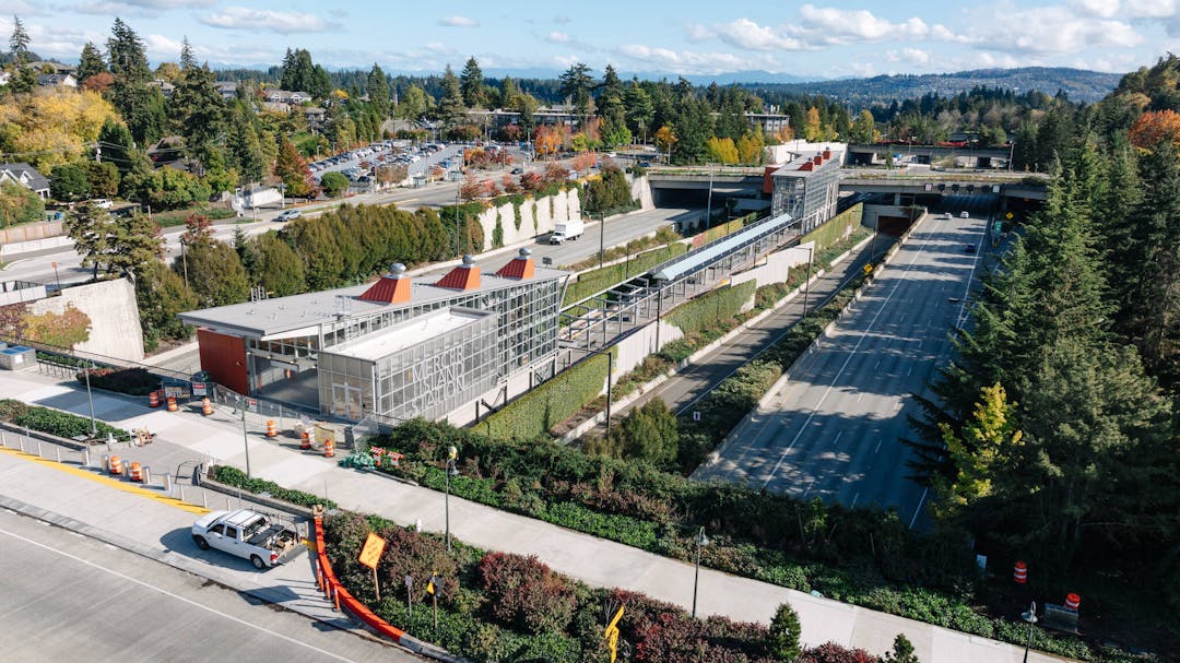
There isn't going to be any new structure that can be defined as a "bus station." The transit interchange is basically just curb space where buses will pull up in front of the existing Park & Ride to allow passengers to connect to the future light rail service (opening in 2023). A roundabout will be constructed to allow the buses to turnaround more easily at 77th Ave and North Mercer Way. There may be a few additional bus shelters added. The major construction that you see in this area today at street level is to build the entrances to the East Link light rail station. As design work advances on the roundabout, more details will be posted here.
Share Why don't Sound Transit and KCM simply skip Mercer Island on the route into and out of Seattle with nearly all the buses except for one every 10 minutes that stops on the island for those that want to get off or on there. on Facebook
Share Why don't Sound Transit and KCM simply skip Mercer Island on the route into and out of Seattle with nearly all the buses except for one every 10 minutes that stops on the island for those that want to get off or on there. on Linkedin
Email Why don't Sound Transit and KCM simply skip Mercer Island on the route into and out of Seattle with nearly all the buses except for one every 10 minutes that stops on the island for those that want to get off or on there. link
Why don't Sound Transit and KCM simply skip Mercer Island on the route into and out of Seattle with nearly all the buses except for one every 10 minutes that stops on the island for those that want to get off or on there.
bill
asked
about 7 years ago
Mercer Island Station
is an important part of the East Link light rail system. Metro has
already planned to completely fill the capacity for bus transfers at South
Bellevue Station and cannot plan for additional routes there. Additionally,
direct service to Mercer Island avoids out-of-direction travel for Issaquah/Eastside
buses, and provides safer, quicker connections to/from the I-90 HOV lanes,
resulting in faster bus travel times and discouraging Eastside drivers from
parking on Mercer Island to reach Link light rail.
Share Will you have to demolish some houses on North Mercer Way to make the bus round about? on Facebook
Share Will you have to demolish some houses on North Mercer Way to make the bus round about? on Linkedin
Email Will you have to demolish some houses on North Mercer Way to make the bus round about? link
Will you have to demolish some houses on North Mercer Way to make the bus round about?
k2moonka
asked
about 7 years ago
The 77th Avenue SE Configuration as approved in
the Sound Transit Settlement Agreement includes the construction of a new
roundabout at the intersection of 77th Avenue SE and North Mercer
Way, replacing the current three-way junction (or T-intersection) at this
location. The roundabout construction will require Sound Transit to
acquire two private properties to the north of the roundabout. Learn more about its property purchasing policies and procedures.
 Construction Phase
 Hearing Examiner Decision_3May2021 (201 KB) (pdf)
 City Letter to Sound Transit Oct 16, 2019 (228 KB) (pdf)